Pittenger property plans go back to designer
The Charlotte Observer gave an update on the development plans of the biggest land area in Belmont in last Sunday’s paper.
 State Senator Robert Pittenger purchased the land from Crescent Resources (Duke Power) several years ago. Crescent had years earlier voluntarily annexed the land into the city limits. Pittenger now is planning to sell the land to real estate developers, “…from up north…”, accrding to the article.
This is a BIG test for the power of the Planning & Zoning Board, city staffers, and the City Council. As council candidate Richard Turner suggests, “…give teeth…to land use plan…”.
One of the Front Porch visitors, settin’ over in the rocking chair, has offered her opinions, some of which we had to edit out or she wooda been pickin’ out pricklies from her behind.

Things came through like, ‘be careful”, “plan of action”, “vision”, and, “get people’s support”, among other things.
Words that politicians use, even in their own personal business dealings can and should be parsed. When Pittenger says, “that’s private”, he is saying, “there is no real buyer, I am trying to run up the price on my property”. The term “real estate investor”, means that capitalism is working at its best. But this form of capitalism affects the quality of life in a community he has never lived in, or spent the night in.
We suggest that everyone should be wary about the term “property rights”, especially in this city election.
8 candidates seek 3 open Belmont seats (Updated)
That’s It ? , that’s all the Observer could write? 
They are not “open”, they are contested.
Is this all that we are going to get from the City Council candidates this year?
You have to buy a copy of the Thursday (10/18)Observer to get more information. To be fair, there is a bit more information from the generic questionaire that was sent to all the candidates.
 Becky Burch: “…she would encourage the development of one shuttered textile mill to be converted into a nursing home…” and this helps the tax rate how?
“Burch said council members have the authority to ask developers to leave room for these areas, she said. They haven’t made that request yet though, she said.” WHY haven’t the council members made those requests – YET ?
We are not making this up – these are quotes from the Charlotte Observer.
 Irl Dixon: “While some candidates say they are concerned about high property taxes, Dixon said the tax rate dropped last year and he expects it to do the same in the future because of the development of high-end, waterfront homes”.
Does this give credence to the term “economic-genocide” that East-enders and South Point residents are concerned about? Push out the existing homes to build McMansions along the lake, reducing visibility and accessibility. This is a concern here in this community.
 Charlie Flowers: “If re-elected, Flowers said he will push for businesses to fill the now empty textile mills”.
Too Late Charlie ! Most of the mills have been torn down or are in the planning stages to be torn down. We cite the examples of the Belmont Hosiery plant – now, called Belmont Reserve. We cite the Imperial Mill – now vacant, and its mill village called Hawthorne. We cite the Acme – now the space for development. This site even had a viable park area that the city acutally refused to use (Woodlawn) in the late 1990’s. How about what once was the Belmont Dyers, now torn down with development plans for high-end housing. Even the cotton warehouse that Stowe Mills used over on Eagle Road (a perfectly good pre-cast concrete structure) was torn down to make way for the clear-cutting that is now known as Eagle Village. Not even going to discuss in any detail the tearing down of the Eagle Mill for $500,000 unsold homes across from Belmont Central.
 Ron Foulk: “…61-year-old political newcomer said council members have budget responsibility…”.
He’s not a newcomer — he has run for City council in at least 2 other elections. He also opposed the Amity Acres annexation into the city in the 1990’s. How can you trust someone who will be opposed to future annexations.
 Curtis Gaston: “He would favor a building moratorium, especially on large subdivisions.”
Once again, the Pittenger/Duke(Crescent) property is already under design – that’s over 1,000 acres of voluntarily annexed land. The city has had jurisdictional control for over ten years on this property and until it was sold to State Senator Pittenger, nothing was done to guide its development direction. Young Mr. Gaston needs to be more involved. He has promise but will he be committed in the long run?
 Martha Stowe: “…It [the land use plan] doesn’t prohibit developers, it just makes sure you’re working in tandem with developers,” she said. “As much development as we’re seeing in Belmont we’re going to have to do something other than what we have done…”
So, what are your plans and ideas?
Richard Turner: “…The recent land-use plan lacks teeth, Turner said, and developers have been able to build as they wanted using conditional zoning. He said the city needs a public facilities ordinance that wouldn’t allow growth beyond the city’s ability to service it…”
Dennis Boyce: “Did not respond”
We hope the BannerNews and the Gazette will expand these questions.
We find it amazing that wherever you see a Burch sign in a yard, there is a Flowers sign right next to it. If it looks like a ticket (signs), sounds like a ticket (identical votes on all issues before council), it’s probably a ticket. Vote for one, get 2. And we thought that the politics in Belmont was “non-partisan”.
Water Restrictions are Serious Business – Please Follow Instructions
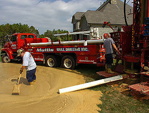
(Charlotte Observer Photo)
Imagine the arrogance of people who think that well water doesn’t affect a community’s ability to conserve its resources.
The city, towns, villages, and county tells you about Stage Restrictions — currently Stage 3, Mandatory — and what do people do? Contract with well-diggers to give themselves a “free source” of water. That recent article (October 11) in the Charlotte Observer, led to a series of letters to the editor that were critical of the practice, give us hope here on the Belmont Front Porch, that not all people are so ignorant or crazy, or both.
Here in Belmont, we have more than one neighborhood that purports to be using well-water for irrigation. This practice must stop !
There have been reports of frantic neighbors here in Gaston County calling insurance companies, well-drilling companies, and county officials about their “dried up wells”. Alledgedly, Gaston County staffers have told property owners that their only resolution is to “drill deeper”.
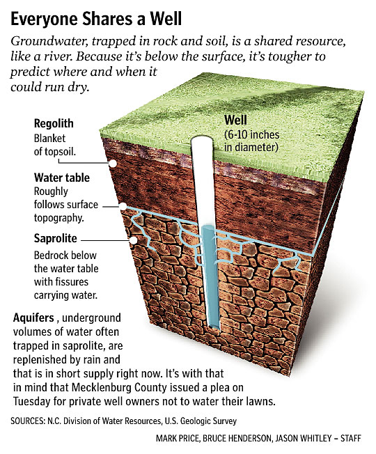
The Observer published a graphic that shows the impact of wells on the aquifer.
We have also published a portion of an article by the US Geological Survey about the relationship of Ground Water and Surface Water. The full article can be retrieved from this link: USGS
The Effect of Ground-Water Withdrawals on Surface Water
Withdrawing water from shallow aquifers that are directly connected to surface-water bodies can have a significant effect on the movement of water between these two water bodies. The effects of pumping a single well or a small group of wells on the hydrologic regime are local in scale. However, the effects of many wells withdrawing water from an aquifer over large areas may be regional in scale.
Withdrawing water from shallow aquifers for public and domestic water supply, irrigation, and industrial uses is widespread. Withdrawing water from shallow aquifers near surface-water bodies can diminish the available surface-water supply by capturing some of the ground-water flow that otherwise would have discharged to surface water or by inducing flow from surface water into the surrounding aquifer system. An analysis of the sources of water to a pumping well in a shallow aquifer that discharges to a stream is provided here to gain insight into how a pumping well can change the quantity and direction of flow between the shallow aquifer and the stream. Furthermore, changes in the direction of flow between the two water bodies can affect transport of contaminants associated with the moving water. Although a stream is used in the example, the results apply to all surface-water bodies, including lakes and wetlands.
A ground-water system under predevelopment conditions is in a state of dynamic equilibrium-for example, recharge at the water table is equal to ground-water discharge to a stream (Figure C-1A). Assume a well is installed and is pumped continually at a rate, Q1. After a new state of dynamic equilibrium is achieved, inflow to the ground-water system from recharge will equal outflow to the stream plus the withdrawal from the well. In this new equilibrium, some of the ground water that would have discharged to the stream is intercepted by the well, and a ground-water divide, which is a line separating directions of flow, is established locally between the well and the stream (Figure C-1B). If the well is pumped at a higher rate, Q2, at a later time a new equilibrium is reached. Under this condition, the ground-water divide between the well and the stream is no longer present and withdrawals from the well induce movement of water from the stream into the aquifer (Figure C-1C). Thus, pumpage reverses the hydrologic condition of the stream in this reach from a ground-water discharge feature to a ground-water recharge feature.
In the hydrologic system depicted in Figures C-1A and C-1B, the quality of the stream water generally will have little effect on the quality of the shallow ground water. However, in the case of the well pumping at the higher rate, Q2 (Figure C-1C), the quality of the stream water, which locally recharges the shallow aquifer, can affect the quality of ground water between the well and the stream as well as the quality of the ground water withdrawn from the well.
This hypothetical withdrawal of water from a shallow aquifer that discharges to a nearby surface-water body is a simplified but compelling illustration of the concept that ground water and surface water are one resource. In the long term, the quantity of ground water withdrawn is approximately equal to the reduction in streamflow that is potentially available to downstream users.
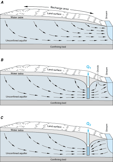
(USGS graphic)
